• Contact
Logo Logo Logo Logo Logo
  • Home
  • Our Story
  • Destinations
  • Travel Stories
    • All Blog Posts
    • Adventure Categories
  • Photography
  • Videos
  • Home
  • Our Story
  • Destinations
  • Travel Stories

    • All Blog Posts
    • Adventure Categories
  • Photography
  • Videos
Bahia Honda State Park, Florida Keys

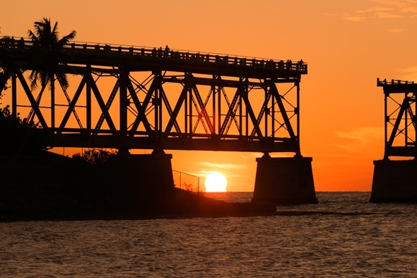
18 Feb Exploring Bahia Honda State Park in the Florida Keys

Posted at 10:46h in Blog, Florida, Outdoor Adventure, The Florida Keys, United States

Bahia Honda State Park is said to be one of the most beautiful state parks in the state of Florida. I haven't visited many of the Florida state parks, but I can see where Bahia Honda would be hard to top. Located about 37 miles...

Read More
About Wander The Map
  • Home
  • Our Story
  • Blog
  • Contact
  • Privacy Policy
  • Terms & Conditions
  • View wanderthemap’s profile on Facebook
  • View wanderthemap’s profile on Twitter
  • View wanderthemap’s profile on Instagram
  • View wanderthemap’s profile on Pinterest
  • View wanderthemap’s profile on YouTube
Subscribe:
Sign up via email to receive our FREE monthly breakdown which includes photo of the month, money saving tips and adventure travel advice!
Follow on Instagram

wanderthemap

Another hike that we went on during our time in De Another hike that we went on during our time in Death Valley National was the Golden Canyon Trail with the Red Cathedral extension! We really enjoyed the landscape throughout this hike—it was another one of our favorite trails in Death Valley. The trail is 1.5 miles each way (3 miles round trip), and the last 0.5 miles of the trail, aka the Red Cathedral Trail, requires some scrambling, ledges, and low overhangs.

The Golden Canyon/Red Cathedral trail was so fun and we loved weaving through, under, and over tight rock formations. Plus, the views at the end of the trail were beautiful. Apparently, some scenes from Star Wars were filmed in this area, and I can see why—it looked like we were walking through an entirely different world!
At first, Badwater Basin in Death Valley National At first, Badwater Basin in Death Valley National Park doesn’t look like much, but when you learn more about this piece of land, it’s quite interesting. Badwater Basin is the lowest elevation point in North America, at 282 ft below sea level. The land here is made up of a salt flat that stretches nearly 200 square miles. If you look hard for the tiny white sign in the mountains in the 5th photo (straight up above the Cruise America RV) you can see where sea level is. Standing on the salt flat and looking up at the sea level sign really puts the low elevation into perspective! We couldn’t help but imagine standing at the bottom of the lake that once covered this area.

We walked about a mile out onto the flats and loved seeing all the salt polygons and unique formations all around us. The farther we walked the less people we saw, and it was quite peaceful during our sunset stroll. We ended up visiting Badwater Basin twice during our trip, and I already want to head back again. There’s just so much to see if you take the time to look!
When standing at the Zabriski Point Lookout in Dea When standing at the Zabriski Point Lookout in Death Valley National Park, you overlook stunning hills and canyons of the Badlands. And if you look close, you might see people hiking far out on the landscape. One of the trails that runs through this area is the Badlands Loop, and it is a fantastic option for a hike!  Wandering through the narrow canyons and up along the hills of the Badlands provides a beautiful vantage point of this colorful area. 

The Badlands Loop is a 2.7 mile trail that runs through the gulch and up along the top of the ridges. There isn’t much shade on this trial, especially if you hike it during the heat of the day, so try to avoid a midday hike here when the temperatures are high. There are several trails that intersect in this area; you can connect to both the Gower Gulch Trail and the Golden Canyon Trail to make it one longer 7.8 mile loop hike. We hiked Golden Canyon earlier on our trip, so this time around we just hiked the Badlands Loop. Photos 1-8 are from the Badlands Loop trail, and 9-10 are from the Zabriski Point overlook the day prior when the skies were much more cloudy!
We spent 2.5 days exploring Death Vally National P We spent 2.5 days exploring Death Vally National Park this past winter, and we sure packed a lot into our visit. Hiking the wide variety of trails was our favorite way to explore the park. All of the trails were fantastic, but the Mesquite Flat Sand Dunes was one of our favorite stops. We visited the dunes several times during our three days in the park, and each visit was at a different time of day. We were there for sunset, at night to see the stars, and at sunrise. When we went for sunrise, we hiked our way out to the summit of the tallest dune. The summit is roughly 1 mile from the parking lot, although there is no formal trail to get there and back. 

Along the hike, we spotted someone painting the sunrise from the top of one of the dunes. We couldn’t help but stop and chat with her and Micah snapped a few photos—we absolutely loved her artwork! We also enjoyed finding lots of animal prints in the sand. Even though the distance was short, the hike was tough as the sand is very hard to walk on. It felt like every step forward equaled two steps back! But the feeling you get from conquering the tallest dune is well worth it. It’s a beautiful portion of the park to explore!
Follow on Instagram
Search


DMCA.com Protection Status

Copyright © Wander The Map 2020